


History
-
Palghar District is a district in northern part of Maharashtra State in western India. On 1 August 2014, the Maharashtra State government announced the formation of the 36th district of Maharashtra, when a new Palghar District was carved out of the old Thane district; it comprised the talukas of Palghar, Wada, Vikramgad, Jawhar,Mokhada, Dahanu, Talasari and Vasai-Virar. At the 2011 Census, the talukas now comprising the district had a population of 29,90,116.
-
Palghar has an urban population of 14,35,210, that is 48% of total population is living in Urbanized Area. The district is bounded by Thane and Nashik Districts on the east and northeast, and by Valsad District of Gujarat state and Union Territory of Dadra and Nagar Haveli on the north. The Arabian Sea forms the western boundary, while Vasai-Virar is part of Mumbai Metropolitan Region.
-
Until 1st August 2014, the talukas now comprising Palghar District formed a part of Thane District. After a struggle and demand for almost 25 years, for bifurcation, the creation of the new district was approved by the Cabinet of Maharashtra on 13th June 2014 and the new district of Palghar came into existence on 1st August. Abhijit S. Bangar was the first Collector of the district. S Suvez Haque was the first Supdt. of Police of the district.
-
The district is the northernmost part of the Konkan lowlands of Maharashtra. It comprises the wide amphitheatre like Ulhas basin on the south and hilly Vaitarna valley on the north together with plateaus and the slopes of Sahyadri. From the steep slopes of the Sahyadri in the east, the land falls through a succession of plateaus in the north and centre of the district to the Ulhas valley in the south. The distance from the parts of different palaces to headquarters Palghar by road is as follows: Khodala 138 km, Mokhada 112 km, Jawhar 75 km, Vikramgad 60 km. The main river flowing through the district is the Vaitarna.
-
The river has many tributaries; two important of them (within the boundaries of this district) are Barvi and Bhatsa. Vaitarna, the largest of Konkan Rivers rises in the Tryambak hills in Nashik district, opposite to the source of Godavari, The river flows across Shahapur, Vada and Palghar talukas and enter the Arabian Sea through a wide estuary off Arnala.
-
Vaitarna River is 154 km long and has a drainage area that practically covers the entire northern part of the district. It has a number of tributaries; the most important of them are Pinjal, Surya, Daherja and Tansa. Ulhas river which flows to Arabian sea is Vasai. Arnala Island is located in Vasai taluka, at the entrance to the Vaitarna estuary
-
Palghar has an urban population of 14,35,210, that is 48% of total population is living in Urbanized Area. Palghar District comprises 8 talukas. The talukas, with their populations at the 2001 and 2011 Censuses are as follows:
Geography
Talukas
| Taluka | Population Census 2001 |
Population Census 2011 |
Taluka | Population Census 2001 |
Population Census 2011 |
|
| Vasai-Virar | 7,95,863 | 13,43,402 | Jawhar | 1,11,039 | 1,40,187 | |
| Palghar | 4,54,635 | 5,50,166 | Mokhada | 67,319 | 83,453 | |
| Dahanu | 3,31,829 | 4,02,095 | Vada | 1,42,753 | 1,78,370 | |
| Talasari | 1,21,217 | 1,54,818 | Vikramgad | 1,14,254 | 1,37,625 |
-
Palghar has one municipal corporation (Vasai-Virar) and three municipal councils (Jawhar, Dahanu and Palghar). At present, there are six Vidhan Sabha constituencies in Thane district, grouped into one Lok Sabha constituency; Dahanu (ST), Vikramgad (ST), Palghar (ST), Boisar (ST), Nalasopara and Vasai constituencies are parts of Palghar Lok Sabha constituency. The Western Railway network passes through Vasai, Palghar and Dahanu talukas of the district.
-
Palghar has India’s first atomic power plant located at Tarapur. The industrial town of Boisar is also home to one of Maharashtra’s largest industrial areas. At Tarapur MIDC. Maharashtra’s largest fishing port is Satpati; Dahanu, Arnala, Vasai and Datiware are also major fishing ports. Dahanu and Palghar are the best known for their chickoo production in the whole of India. A special Chickoo festival is also hosted in Palghar and Dahanu.
-
Vasai-Virar is a city and tehsil (subdistrict) in Maharashtra state in western India, comprising the most populated part of Palghar district. It is a suburb of Mumbai. According to the 2011 census, it is the fifth largest city in Maharashtra. It is located in Palghar district, 50 km north of Mumbai. The city is located on the north bank of Vasai Creek, part of the estuary of the Ulhas River. Vasai-Virar City Municipal Corporation (VVMC) covers the tehsil. Vasai-Virar is an agglomeration of several, formerly separate, towns. The area covered by the city roughly corresponds to the ancient city of Sopara.
-
The Vasai-Virar Municipal Corporation (VVMC) was formed on 3rd July 2010. It is headed by a Municipal commissioner, an Indian Administrative Service officer who wields the executive power. A quadrennial election is held to elect the governing body, who are responsible for overseeing that their constituencies have the basic civic infrastructure in place, and that there is no lacuna on the part of the authorities. The position of mayor is a largely ceremonial post with limited duties but the office-holder heads the party with the largest vote.
-
Palghar pronunciation is a town and a Municipal Council located about 87 kilometres north off Mumbai. Palghar lies on the Western Line of the Mumbai Suburban Railway on the busy Mumbai-Ahmadabad rail corridor. It is the administrative capital of the newly formed Palghar district. The town is located around 35 kilometers north of Virar and about 20 kilometers west of the Mumbai-Ahmadabad National Highway (NH 8) exit at Manor. Palghar, which was until 31st July 2014 known as a distant suburb of Mumbai has been accorded the status of a district headquarters following the formation of the Palghar district on 1st August 2014. It is Maharashtra’s 36th district. Palghar remains a popular weekend getaway town for Mumbaikars. It is also an emerging town with high growth prospects located within the periphery of the Mumbai Metropolitan Region.
-
Located nearly 40 kilometers away from Virar, Palghar acts as an important residential, industrial and educational hub for villages surrounding the town. Various age groups of people travel from the surrounding villages for different job opportunities, education, business, shopping and health care facilities. Many villages are connected to Palghar via road & rail. The government provides State Transport Bus facility to access these villages. Various villages surrounding Palghar include Tarapur, Umroli, Kelva, Satpati, Shirgaon, Saphale and Sartodi.
-
Dahanu is located 65 kms north of Virar on the Western Railway line of Mumbai Suburban Railway. It can be reached from National Highway NH-8, 24 km off from Charoti Naka. It is 22 km North of Boisar on the Western Railway line. It has nice and beautiful beaches. There is nice beach at Parnaka. Nearby Sai temple is located in Narpad. Also famous for Mahalaxmi Temple located just 4 km from Charoti.
-
The name “Dahanu Gaon” originates from the word “Dhenu Gram” meaning the village of cows. A lot of cattle, particularly cows were owned by the people in Dahanu. Today, Dahanu has become a major commercial and industrial town in the Palghar district. It is well known for rose gardens, coconut groves and the chickoo fruit and accounts for over 35% of India’s chickoo production. Rubber balloons, rice mills and manufactured goods, are major manufacturing products which are produced in Dahanu.
-
There is also a 500-MW power plant that supplies electricity to Mumbai. The electricity is distributed by Reliance Energy. It was formerly owned by the government. Dahanu, a peaceful seaside town with a sprawling, uncluttered beach. The Dahanu-Bordi stretch is 17 km. This once-barren territory thrived under Irani settlers, an down to earth people. Dahanu is lined with fruit orchards and is favored for its chickoo fruit. Accessible from Dahanu is Udwada—an significant place of worship for the Zoroastrians—with a large, nifty temple that houses their sacred fire. This fire has been kept alive for almost a thousand years.
-
Dahanu is located at 19.97°N 72.73°E. It has an average elevation of 9.89 metres. To the west of the town is the beautiful coast of the Arabian sea while the east is lined with the magnificent Sahyadri ranges. This unique combination has made Dahanu a major tourist attraction. Sprawling Chickoo wadis (farms), rose gardens, salt pans are among the other things that dot the landscape.
-
Talasari is a city and a municipal council in Palghar district in the Indian state of Maharashtra. It is one of the talukas of Palghar district.
-
Jawhar is a city and a municipal council in Palghar district in the Indian state of Maharashtra. One of the oldest municipal council of maharashtra state was formed in 1918. It is about 145 km from Mumbai and 80 km from the city of Nashik.
-
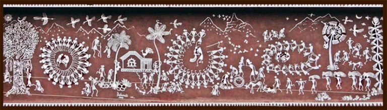
Jawhar is a hill station located at an altitude of 518m., situated in newly formed Palghar district, Jawhar is known for its picturesque setting and a vibrant cultural heritage. It is also known as the ‘Mahabaleshwar’ of Thane district but now in Palghar district. It is one of the very few tribal regions of Maharashtra and is famous for its vibrant Warli paintings that are a characteristic landmark of this place.
-
The palace was build by Raje Yashwant Rao Maukne.The stone used for this is syenite which was brought from sakhara which is 12km
-
Mokhada is a census town in Jawhar subdivision of Palghar district in the Indian state of Maharashtra. It is about 65 km from Palghar.
-
Vada or Wada is one of the eight talukas of the Palghar district in the Indian state of Maharashtra. This is the industrialised taluka in palghar district. Earlier Wada was known as Kamalpur. Wada is located at 19.65°N 73.13°E. It has an average elevation of 38 metres (124 feet).
-
Vikramgad is a census town in Jawhar subdivision of Palghar district in the Indian state of Maharashtra. It is also known for a weekend picnic spot. Nature Trails is the good picnic place in Vikramgad. One can reach Vikramgad from three ways like from Wada, Jawhar and Palghar. It is a Taluka place. Vikramgad is also famous for Weekly Bazaar on Wednesdays called as Budhwar Bazar in local language. Nowadays the major source for travel is by private vehicles like Jeeps, Six seaters and of course bus service is also available.